Lab Resources
Module 3: Human Interaction with the Landscape Active Learning Lab
Shelley E. Rose
This active learning lab will introduce students to active learning strategies for thinking about human and physical geography.
Learning Objectives
Students will learn
- what it means to have a “maker mindset” and power of learning through experience
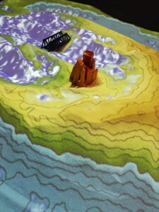
- to operate the Augmented Reality Sandbox and use it to explore physical and human geography
- to read topographical maps
- apply understandings of geographic risk, weathering, and topography to experiments with the AR Sandbox
Materials
AR Sandbox (see this resource collection about teaching with the AR sandbox https://referatory.cleteaching.org/items/browse?collection=25)
3D Printers (reserved in CSU MakerSpace)
Thingiverse (see examples of structures in the UT-Knoxville link)
Blackboard (to submit lab questions)
Procedure
Class 1 (Duration 1 hour, 15 minutes)
With your lab group, visit these three active learning lab stations before the end of the class session.
Introduction & Instructions
- Before and during class, revisit the units in Module 2 and Module 3 on weathering and erosion, risk, and geography of Northeast Ohio as needed.
- Sit with your lab group in the Makerspace. Decide which station you would like to visit first.
- Up to 2 lab groups (around 10 students total) will visit the AR Sandbox at a time
- Answer the questions from each station in Blackboard. You will work together as a group, but each student will submit their own answers to Blackboard.
Station 1: Augmented Reality Sandbox
-
- Listen to the overview of the AR Sandbox
- 5 minutes for students to “play” with the Sandbox
- Work through lab questions with the Sandbox and submit answers to Blackboard
- Once all the lab group have cycled through the station groups and individuals can revisit the sandbox as needed.
Lab Questions
- What does the AR Sandbox do?
- What do the colors represent?
- What do the lines represent?
- What happens when you hold your hand over the box?
- Place an object in the sandbox. What happens when you intervene in the landscape?
Station 2: Risk and Human Interaction
-
- Remember what we learned in class about human interaction with the landscape and geographic risk
- Think through cases of geographic events such as flooding or watersheds
- Look through the topographic maps of Northeast Ohio
- Pick one to try and mimic in the sandbox for your team
Lab Questions
See this guide to reading topographic maps https://paleoind.sitehost.iu.edu/Resources/Guide%20to%20Topographic%20Maps.pdf
6. What is the title of your map?
7. Who is the cartographer?
8. When was it created?
9. Name two physical features of the map that you think will work well in the sandbox
10. Give an example of a geographic event that affects topography
-
- Brainstorm potential human interactions with the landscape in these cases
11. Provide an example of how humans intervention in the landscape. What are the potential consequences?
-
- Develop a group plan for 3D printed structures to try in Sandbox- what might you print that humans add to the Earth’s surface?
12. What will you add to the sandbox landscape? What do you think will happen?
Station 3: 3D Printing Station
- Listen to the overview of the 3D printing process
Lab Questions
13. What will you 3D print? Do you have all the files needed?
14. How long will it take?
15. What do you expect the outcome will be like?
Class 2 (Duration 1 hour, 15 minutes)
Review of Class 1 activities
Reflect on and complete any activities from Class 1
Station 1: AR Sandbox Station
- Students will bring objects they 3D printed or brought from outside of class to try in the sandbox
Lab questions
1. What did you print/bring for the sandbox? Where will you put it in the topography and why?
2. What do you expect will happen? What did happen?
3. How does the AR Sandbox connect to the model curriculum for your grade level(s)? How does it foster spatial thinking?
-
-
- Use the Ohio Department of Education Model Curriculum https://education.ohio.gov/Topics/Learning-in-Ohio/Social-Studies/Model-Curriculum-for-Social-Studies
-
Station 2: Risk and Human Interaction Station
-
- Evaluate the objects and their relationship to the landscape.
Lab questions
4. How do these objects relate to geographic risk or the equation for geographic risk?
5. What have you learned about human interaction with the landscape? or what has this lab reinforced about human interventions in the landscape?
Station 3: 3D Printing Station
- Retrieve your printed items from the Makerspace manager.
Lab questions
6. What did you 3D print? How did the object come out? What does it look like? How long did it take? Did this surprise you?
7. Would you do the same print again? Why or why not?
Works Cited
STEMBot, “What is a Maker Mindset?” STEM Minds, April 17, 2017. Accessed November 6, 2023. https://www.stemminds.com/what-is-a-maker-mindset/
GIS Lab University of Tennessee, Knoxville. “Teaching with the AR Sandbox in Higher Ed.” Accessed October 10, 2023. https://gislab.utk.edu/outreach/ar-sandbox/teaching-with-the-ar-sandbox/
P. David Polly, “Reading Topographic Maps: Adapted from Guide by Boris Vasilev, Paradise Valley Community College, Phoenix, Arizona,” Department of Geological Sciences, Indiana University, Accessed November 6, 2023. https://paleoind.sitehost.iu.edu/Resources/Guide%20to%20Topographic%20Maps.pdf
