Cleveland has been called the city of bridges. While there is no single spectacular bridge to catch the attention of the citizen, Cleveland offers a unique mixture of bridges. Within a single view, it is often difficult to limit one’s vision to only a single span. The panorama of Cleveland’s Cuyahoga Valley shows bridges of all sizes, styles, functions and types. To narrate the history of these bridges is the purpose of this book, dedicated to the engineers of the past and present.
Bridge building in Cleveland and its surrounding suburbs is in some ways typical of that of any metropolis located on a major waterway. Almost all important urban centers developed adjacent to water. London, Paris, Rio de Janeiro, Moscow, New York, Chicago, Pittsburgh, Detroit, San Francisco are typical. But in other ways Cleveland is atypical. First, because Cleveland has long been a port on the Great Lakes, now served in addition by the St. Lawrence Seaway. Second, because the Cuyahoga River literally cuts the city in two, and was the dividing line between treaty land and Indian Territory. Third, because Cleveland is a steel manufacturing center, and the Flats area has a utilitarian use, and finally, because the pattern for bridge design seems to have been formed early in the nineteenth century. The city has remained conservative in its architectural style because of its Yankee roots. Every town, village and city has its own peculiar environment — one that is unique, for it has been formed by the topography, by the life — functions of its businesses and industries, and most important of all, by its inhabitants who through the generations have molded a cultural environment. There is an intangible “climate” that permeates a given community. Here then is our thesis: we are chronicling a history of bridges, but with special attention to the influence of our environment upon them. By discovering this influence as it, has operated in the past, we can design and build with better understanding for the future.
The First Bridges: 1800 to 1900
The Geological history of the Cuyahoga Valley is one of the factors which concern the engineer. In the glacial period, the ice — mass, as it moved southward, carried with it vast forests, rocks, sand, gravel, soil — and left the debris as the ice — mass thawed. The granite boulders, not uncommon on the surface of the sandstone region of Northern Ohio, had come from Canada. After the glacier had plastered these deposits over the land, nature created a new drainage system. In the course of time, a hundred centuries or more, the valleys of the Cuyahoga, the lesser streams, and the ravines of the locality were cut by the force of running water. The lower part of the Cuyahoga River now flows to the lake along a deep, preglacial valley, far above its ancient bed.
The first white settlers were confined to the eastern bank of the Cuyahoga River. The west side was still Indian Territory and remained so until 1805 when the State of Connecticut resolved the problem, by finally allowing the “Firelands” of Erie and Huron Counties to be opened to settlement by the descendants of the Revolutionary War victims.
Moses Cleaveland and his forty-nine followers entered Ohio on 4 July 1796. They were surveyors enlisted by the Connecticut Land Company to survey an area in Western Reserve called the New Connecticut. When they reached the mouth of the Cuyahoga in mid — September 1796, they advanced a little way up its channel and “…attempted to land, but in their efforts to do so they ran their boat into the marshy growth of wild vegetation which skirted the easterly bank of the river and stranded here…”[1] The place where they landed was the end of an old Indian trail at the foot of what is now St. Clair Avenue, on the east bank near the present Detroit-Superior Bridge. In about a month the town site had been surveyed, its street plan laid out, and a couple of cabins built. Thereafter, Moses Cleaveland seemed to have had little interest in this venture, for he never returned. In 1796 the wrote, “While I was in New Connecticut I laid out a town on the banks of Lake Erie, which was called by my name, and I believe the child is now born that may live to see that place as large as Old Windham”; (which was his hometown). He might have borrowed this opinion from Benjamin Franklin, who “from his studies of conditions, pointed out the site of the future Cleveland as the place at which an important city was to arise.[2]
Moses Cleaveland’s party had two married couples. One Elijah and Anna Gun (sometimes spelled Gunn) took charge of the supply station at Conneaut. The other, Job and Tabitha Stiles, became the first husband and wife to live in Cleveland. In the following year, 1797, Elijah Gun came to Cleveland and for years operated a ferry across the river at the foot of Superior Street, the only easy way to reach the West Side. The town had a hard time growing up, for Cleveland had the reputation of being malaria — infested. New arrivals preferred the high land near the village of Newburgh or the settlement of Doan’s Corners. Another reason was that the Connecticut Land Company doled out the balance of the land within its purchase by lot to the stockholders, each competing with the other to sell their land. For example, Eli and Strong were founders of cities now known as Elyria and Strongsville that offered good farm land of clay soils, in contrast with the sandy soils of Cleveland.
The West Side was accessible only by ferry. A settlement called Brooklyn (later Ohio City) was allotted by Samuel P. Lord as part of his purchase and, and his brother-in-law, Josiah Barber. West Side land speculations began in 1831, when the Buffalo Company bought a large tract of land, laid out streets and put in improvements. The most important venture of the Buffalo Company was a ship canal from the Cuyahoga River to the Old River bed, enabling boats to enter a protected harbor on the West Side. Lord and Barber, who became mayors of Ohio City, founded the Cuyahoga Steam Furnace Company, and early manufacturer of steam engines for lake vessels.
Henry S.W. Wood states that the “…crossings of the Cuyahoga River in the earlier days were made over bridges of crude construction …a stringer bridge spanning the river, with a rope to steady the person making the passage…”[3]
One of the first bridges across the river was at Center Street, the old ferry landing. This was a floating bridge made of large whitewood logs chained together. When a ship wanted to pass, a section of the bridge was floated to one side and, after the vessel had passed, was drawn back into place by ropes. One spring this bridge was carried out into the lake by a flood. The structure was replace by a pontoon bridge made of flat boats chained together. But another flood carried this one away also. It was succeeded by a wooden structure which in due time suffered the same fate.
Elroy Mckindree Avery, in his article, “The Early Bridges of Cleveland”, believed that the earliest mention of a fixed bridge was one found among old papers and documents belonging to Wileman White, who came from Berkshire County in Massachusetts to Cleveland in 1815 and died here in 1841. The document, dated “Cleaveland, November 16th, 1821”, is given in full in Avery’s article. Thirteen subscribers promised to pay “a certain sum applied to their signatures for the purpose of erecting a free bridge across the Cuyahoga River, at the line between the lands of Leonard Case and Noble A. Merwin.”[4] None of the subscribers contributed money; eight promised wheat, four promised work, and one did not specify. Judge Henry C. White, who found the letter among his father’s papers, now in the Western Reserve Historical Society, believed his father to have been the builder of the bridge. Nothing more is known about it.
In 1832 the opening of the Ohio Canal from Cleveland to the Lake to Portsmouth, Ohio, — seven years after it had been started — brought increased traffic and sudden growth to the young village. In 1832 the population of Cleveland was 1500; but it grew rapidly in the five years following the opening of the canal. This is evident from and early map published by N. Currier (later Currier and Ives) showing the “Port Statistics.” This growth can be attributed to the Erie Canal through the state of New York as well as the Welland Canal around Niagara Falls. The Ohio Canal carried the farmers products to Cleveland. The Erie Canal continued the haul to New York City.
In the following year, James S. Clark and Associates laid out, as the main thoroughfare, Columbus Street to the river, through what was then called Cleveland Center. Streets radiating like spokes of a wheel were named after foreign countries — Russia, British, China, German, French.
Many of these street names still survive. Each had a little alley behind the street, and all converged on Columbus road at the proposed river — landing called “Gravity Place”. Even Leonard and Case Streets are side by side along the river in honor of Leonard Case, Jr. Several years later, the group allotted what these entrepreneurs called Willeyville, in honor of the first mayor of Cleveland, and through this section, laid out an extension of Columbus Street as far as West 25th Street — the “Wooster and Medina Turnpike.”
Having graded the new street to the river, they spent $15,000 in 1835 to erect a bridge connecting the two sections of the Columbus Street properties.
This bridge, the first important structure across the Cuyahoga, formed the final link in a short route to Cleveland from the south and west, practically sidestepping Ohio City. A description of it, stated in the first city directory printed in 1837, reads as follows:
The bridge was supported by a stone abutment on either shore and piers of solid masonry erected in the center of the river. Between the piers, there is a draw sufficient to allow a vessel of forty-nine feet beam to pass through. The length is two hundred feet, the breadth, including the sidewalks, thirty — three feet, and the height of the piers, above the surface of the water, may be estimated at twenty-four feet. The whole which, with the exception of the draw, is roofed and enclosed, presents an imposing appearance and reflects much credit on the architect, Mr. Nathan Hunt..[5]
We also have a contemporary picture of the Columbus Road Bridge [Figure III]. In 1835 it was the most remarkable structure in Ohio. Visitors
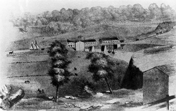
from all over the state came to view it and gasped at the work which had cost the enormous sum of $15,000 to build.
In 1836, first the City of Ohio and then the Village of Cleveland were incorporated, and the rivalry between them grew tense. The merchants of Ohio City were entirely willing to have the Columbus Street Bridge, but they also wanted one at Center Street, and so there came into being the famous slogan “two bridges or none.” What resulted was the Bridge War, celebrated in the annals of Cleveland. In 1837 the Cleveland City Council directed the removal of its half of the old floating bridge at Center Street. This was an attempt by Cleveland to divert all through traffic to the Columbus Street Bridge, thereby by-passing Ohio City. The mandate of the council was carried out at night, and, when the people of Ohio City realized what had happened, they were enraged. At and indignation meeting they declared the Columbus Street Bridge a public nuisance.
Their Marshall directed a posse of deputies, who damaged the bridge by a charge of powder under the Ohio City end, damaging it only slightly. Then the marshal with his deputies marched to the Cleveland side of the bridge, dug up a deep trench at the approaches, and damaged that end, thus rendering the bridge useless. Ohio City held a council of war and staged an all-out attack upon the bridge. Nearly a thousand men, armed with clubs, rocks, and rifles marched to the bridge, accompanied by a chaplain and a lawyer.
But Cleveland had learned about the attack from scouts. The Ohio City posse found itself confronted by a company of militia with muskets. Even an ancient cannon had been rolled down to the river’s edge. At this point John W. Willey, first mayor Cleveland, stepped forward, but before he could utter more than a few words, he was greeted by a volley of rocks, and the fight started.
At either end of the bridge was an apron that could be raised or lowered, and the one at the Ohio City side was let down to provide a shelter for the anti-bridge forces. The men went at their destructive task, ripping up planks and throwing them into the river. One Ohio City man named Deacon House picked his way through the Cleveland lines and spiked the cannon with an old file. He became quite the hero of the Battle of the Bridge.
Some men were injured but none killed. Finally the fray was stopped by the Cleveland marshal, who also was sheriff of the county. He took possession of the bridge, obtained a court order against further interference, and posted guards at either end to maintain free movement of traffic. This Battle of the Bridge produced a poet — laureate in D. W. Cross, who wrote a mock — epic poem, in heroic couplets, entitled “The Battle of the Bridge,” which was published in the Magazine of Western History. Its model was Alexander Pope’s Rape of the Lock. We have space here to quote but a few of the stanzas:
On hills, like Rome, two cities might be seen,
(Meand’ ring Cuyahoga flowed between);
Whose rival spires in rivalry arose,
The pride of friends, the envy of their foes.
Each rival ruler of each rival town
On his would smile, but on the other frown.
Each sought for greatness, in his rival’s fall,
Regardless that the world was made for all.
Envy and hatred waxed to frenzied height!
Naught could appease but fierce and bloody fight.
The culmination came!
A peanut stand Erected by a “combination” band
Of desperate men of capital, who swore
No trade should be diverted from their shore.
They claimed that Clark and Willey, reckless, sought
To build a bridge. The right of way was bought
Already! and they then designed to build Columbus Street and
bridge! This rumor filled
Their souls with madness, and their eyes with tears! To think
that peanut stand, the toil of years
Should for the want of patronage decay
And trade and barter turn some other way
They all agreed this could not be allowed.
And boisterous bellowing agitate the crowd!.[6]
The result of the bridge war was that the West Siders gained their point, and two bridges were provided. The Center Street Bridge was completed after much discussion and the Columbus Street Bridge was equipped with a movable center span.
The Columbus Street Bridge of 1835 marked the beginning of the first period of bridge building over the Cuyahoga River — bridges of wood with masonry piers, designed for wagon traffic. As late as 1835 there were still three of these: the Columbus Street Bridge, one at Seneca (West Third) Street, and one at Division Street (Center Street). There was agitation for a new at Columbus Street, but because the two towns could not agree on a plan, the county re-built the span. In 1854 Cleveland annexed Ohio City. And immediately after annexation, Cleveland built the Main Street Bridge, rebuilt the Center Street Bridge, and constructed the Seneca Street Bridge. In 1870, a third Columbus Street Bridge was erected — an iron truss bridge which was replaced in 1895 by number four in the series.
The Seneca Street Bridge, one of the earliest, was a wooden structure that collapsed in 1857 under a load of cattle. A new timber structure, with a draw operated by hand, replaced it. In 1888 the third bridge at this site, this time an iron one with a pivot span of 180 feet and one fixed span of 105 feet, was built. The fourth one was a Scherzer roller lift bridge, the first one of its kind in the city. This bridge, designed by a Chicago firm, was opened to traffic on 25 June, 1903. It had a roadway about twenty-three feet wide, with two six-foot sidewalks.
The history of the Center Street Bridge is similar. This was the original crossing of floating logs that were drawn aside for ships. In 1853 a wooden draw span was built, but it had to be replace five or six times until 1900, when a steel bridge was erected. This bridge is the only remaining swing bridge in the Cleveland area. Although the deck has been replaced with and open mesh at one end and concrete at the other to counterbalance the unequal lengths of the spans, it continues to serve heavy truck traffic that sets the light bracing to dancing under impact. Because of the obstructing pier in the middle of the waterway, this type of bridge is no longer being built.
And so the need for bridges kept pace with the growth of population and commerce. Particularly significant was the peace-making role that the bridges across the Cuyahoga River played in attempting to join together the two communities for better or worse; after river navigation had been improved by eliminating the sand bar and opening a new outlet, moveable bridges were necessary to accommodate shipping. The channel width dictated the type of bridges to be built.
Perhaps even more important than the local roads to the growth of the young city was the construction of the railroads beginning in the 1850’s. The iron horse demanded more bridges to cross the valleys and the rivers of northeast Ohio to link Cleveland with the rest of the nation. Some of the railroad bridges will be discussed later.
- Elroy McKendree Avery, "The Early Bridges of Cleveland", in Bridges of Cleveland and Cuyahoga County (private printed, Cleveland, Ohio, 1918). p. 24. ↵
- William Ganson Rose, Cleveland: The Making of a City (World Publishing Company, Cleveland, Ohio, 1950) p. 26. ↵
- Henry W.S. Wood, "The Old Detroit-Superior Viaduct", in Bridges of Cleveland and Cuyahoga County, p. 14. ↵
- Avery, "The Early Bridges of Cleveland," pp. 24-25. ↵
- Ibid., pp. 26-27. ↵
- George E. Condon, Cleveland: The Best Kept Secret (Double-day and Coo., Garden City, New York, 1967) pp. 46-54. ↵