Chapter Two: The Middle East and the Impact of Imperialism
Part 1. The Middle East and the Impact of Imperialism

Visual Aids for Chapter 3. Imperialism
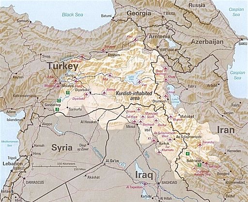
Map: Kurdish Territory
Key Figure: Mossadegh
Key Figure: Ayatollah Khomeini
Images: Modernizing Leaders (Atatürk, Reza Shah and Amanullah Khan)
Key Figure: Gamal ‘Abdul Nasser
Maps: NATO and other Alliances/Treaty Orgs
The Middle East Map of Today
After the First World War, the contours of the major nation-states of today’s Middle East were delineated. The Paris Peace Conference of 1919 solidified the political boundaries that later became the countries of the Middle East. At the same time a movement to recognize the sovereignty of colonized countries let to the creation of mandates based on the territories ruled by European countries, with the idea that they would develop toward independent status.
Many promises were left unfulfilled, however, as cultural communities such as the Kurds were left with no territory of their own. To this day, the Kurds are a “stateless nation”, with their territory spanning across 4 nation-states: Turkey, Syria, Iraq and Iran (see map, below). We cover the concept of a stateless nation and provide other examples in this chapter as part of a discussion on the national identities of the Middle East of today.


