Main Body
ANCIENT FORT, NEWBURG
This consists of a double line of breast works with ditches across the narrow part of a peninsula, between two gullies, situated about three miles south-easterly from the city, on the right of the road to Newburg on land heretofore owned by the late Dr. H. A. Ackley. The position thus protected against an assault, is a very strong one, where the attacking party should not have projectile of long range.
On three sides of this promontory, the land is abrupt and slippery. It is very difficult of ascent, even without artificial obstructions. Across the ravine, on all sides, the land is upon a level with the enclosed space.
The depth of the gully is from fifty to seventy feet. About eighty rods to the east, upon the level plain, is a mound ten feet high and sixty feet in diameter. At the west end of the inner wall is a place for a gateway or passage, to the interior.
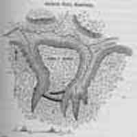
The height of the embankment across the neck is two feet, and the enclosed area contains about five acres. Perpetual springs water issue from the sides of the ravine, at the surface of the blue clay, as they do at Cleveland.
About six miles from the lake, on the eastern bluffs of the Cuyahoga river, is a similar work that has but one line of embankment, with a ditch. The bluffs are higher, but not quite as inaccessible as on the Ackley farm. About the middle is an unexcavated space across the ditch, but the breast work has no gap for an entrance.
Two miles farther up the river, on the same side, is third work, in the same style, similarly located, but enclosing about twice as much space. The general figure of the enclosure is very much like the one on Ackley’s premises. Two small branches head ear each other at the upper end of two ravines, from one hundred to one hundred and fifty feet deep. Across the neck are two parallels, which have been nearly obliterated by cultivation. the inner parallel does not appear to have been as high as the outer one, and between them was a broad, but not a very deep ditch. A conspicuous ditch was made on the outer side of the outer wall, from which, no doubt, the earth was taken for the embankment. There are no gateways in either of the walls.
A much stronger and more elaborate fortified position, exists in Northfield, Summit County, on the river bluffs, two miles west of the center.
A road leading west from the center to the river, passes along a very narrow ridge, or “hogs back,” between two gullies, only wide enough for a highway. Before reaching the river bluffs, this neck of land expands right and left, where there is a level space of about two acres, elevated near two hundred feet above the canal and river.
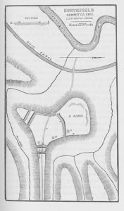
Where this area begins to widen out on the land side, there are two lines of banks, with exterior ditches, which are forty feet apart, and extend across the neck, without entrances or gateways. From the top of the breast work to the bottom of the ditch, is now from four to five feet. Mr. Milton Arthur, the owner of the land stated, that before the land was cultivated, a man standing on the ditch could not look over the wall. On all sides, the flat land is bounded by gullies, eighty to one hundred feet deep, except where it is joined to the ridge.
There is permanent water in the ravines. The earth of the bluffs is so steep that it is subject to slides. It is remarkable that there is, within this area, another set of lines on the side towards the river, reducing the fortified area to about one-half the space, whose edges are at the bluffs. Two projecting points art cut off by these lines, and left outside the woks. In this way, much of the natural strength of the position is lost. At these places, there are pits, which the early settlers of Northfield say were filled with water, and were stoned around like wells. There are also two low mounds, m, m, on the east side. Where the bluff is not as steep as it is elsewhere, there is a parapet thrown up at the crest. A part of earth on the north side and west side, was taken from the inside, which indicates a state of siege, or at least some pressing haste when this part of the line was finished. Perhaps their enemies had gained a foothold in the level space outside the lines.
On the west side of the river is another ancient fortification, opposite this, and it is stated there is in the township of Independence, on the bluffs, north of Tinker’s creek, near its mouth, another work of the same character. There are no doubt others which are known to inhabitants not yet surveyed or described.
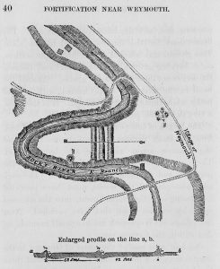
A short distance east of the village of Weymouth, in a bend of the Rocky River, is a fortified point of land, with three lines of banks and ditches. From the outer to the middle one is forty-two feet, and thence to the inner parallel, thirty-eight feet. In 1850, the outer and the inner lines were in the best condition. From the top of the outer wall to the bottom of the ditch, is five feet; of the middle one four feet, and the inside parallel six feet. The excavations for the ditches reached to the slate. This ground was selected by the first white settlers, for a burying ground, but was abandoned because the soil is not deep enough for graves. Around the bend in the river is a deep channel, with vertical rocky walls, thirty to fifty feet high. It is therefore, a very defensible position.
The length of this peninsula is three hundred feet, from the inner parapet to the extreme front, and the distance across the base, one hundred feet. There are no openings or gateways through the parallels, and no breaks in the ditches. The engineer who planned the works, must have provided for passing over the embankment, into the enclosed space, by wooden steps, that have perished. Near the village of Weymouth are five small mounds, m, and within the fortress, one.
One-half mile east of the center of Granger, in the same county, is a low circular enclosure, about three hundred feet in diameter. It has a slight exterior ditch. There is an opening for entrance on the north-west side, near where the east and west road crosses the work. Two small streams of living water pass along the sides of it. The situation is low and flat, with a slight rise on the west, which overlooks the interior of the enclosure. It possesses no natural strength of position, and was doubtless designed for other purposes than defence.
