Main Body
PRE-ADAMITE HISTORY
History, under a strict definition, should include nothing more than the record of human transactions, but I here venture to introduce an article which relates principally to natural science.
The wells, springs, cisterns, and sewers; the general improvement of our streets; the protection of the lake shore and the state of our harbor, are all influenced by the geological structure beneath us. I imagine, also, that it will be interesting to look briefly at the cause of the most recent geological changes.
On the gravelly plain which was selected by the surveyors in 1796 as the site of a future city , there are numerous low, sandy ridges, which are parallel to the shore of the lake. These ridges were the first roads of the pioneers on their way to the west. They appear to have been formed beneath the surface of the water at a remote period, when the lakes had a much higher level than now. On all sea coasts long, narrow sand-bars are known to form, a short distance from the shore and parallel with it.
Their position is indicated to the navigator by the outer line of breakers. The formation upon which this city rests is geologically the most recent of all, except the alluvium.
There are trees, sticks, and leaves imbedded in it, which have not yet perished; but in reference to the period of written history its era is very ancient. It was formed after the earth had assumed substantially its present surface, in a topographical sense. Geological investigations show conclusively, that since the era of the coal, the chalk formations, and even the tertiary beds, there was in the northern hemisphere, north of about 40°, a period of universal ice; as there is now in Greenland.
As that frozen age was disappearing the more ancient and solid rocks of the Carboniferous, Devonian and Silurian ages, on which the universal glacier rested and moved; were ground down, scoured and polished. The crushed and pulverized materials of the rocks form what is commonly called earth, as distinguishable from indurated strata. In the northern hemisphere, the ice movement was toward the south, which carried the fragments of rocks and their mixed debris, in the form of dirt. Always towards the equator.
In this way we have here pieces of rocks designated as “boulders” or lost rocks; which were originally in place on the shores of lake Superior or Hudson’s Bay.
Our soil is composed of the disintegrated particles of these rocks, mingled with the crushed portions or strata nearer home. The surface formation on which the city stands belongs to the close of the of the ice period when the glacial masses were disappearing, and the waters were assuming their present level over the land. It is sometimes called “post-tertiary,” or “quaternary,” but more often “northern drift.” There are in it no rocky beds, although it is frequently stratified, and laminated. The waters from which, by a joint action with moving ice, it was transported and deposited, were throughout the upper lake country wholly fresh. Numerous shells have been found in it, all of which belong to fresh, and none to sea water. Nearer the ocean, the shells of the drift are of marine origin. Throughout all the region of the upper lakes, there are numberless trees, logs, sticks, branches and leaves scattered through the drift formation. It is composed of red, blue and dun colored clay, on which rests coarse sand, gravel and boulders.
By an analysis of the laminated blue clay taken from the foot of Ontario street, made some years since it was found to contain:
Silex and Alumina, 77.50
Carbonate of lime, 6.00
Carbonate of magnesia, 9.50
Sulphide of iron, 3.50
Vegetable matter and loss, 3.50
————
100.00
An analysis of the red laminate clay of lake Superior gave a similar result, except in regard to the red oxide of iron which exceeds that of the lake Erie clay, and which is the cause of its red color.
The drift clays always contain alkalies, sometimes in sufficient quantities to prevent their being used for the purpose of making brick.
Sometimes it changes to a compact hard-pan, composed of clay and fragments of rocks. There are boulders and pebbles of northern rocks throughout the whole mass. In many places it is not stratified, but mixed and confused like the moraines of Alpine glaciers now being formed. There are places in the valleys of the upper lakes where the drift is 600 and 800 feet thick, but here, it is probably nowhere more than 150 feet, down to the underlying rock. When lake Erie receded to its present level, its ancient bed was partly inclined like the rim of a basin sloping towards the water.
The mouths of the rivers were farther out than now, the lake was smaller in size and its shore line quite different. Where the shore was composed of marly clays, as it is along much of its outline, the waves made rapid inroads upon it and the soft materials were dispersed by currents that exist in all bodies of water. There is a tradition that when the French first coasted along the south shore of lake Erie, the Indians remembered when there was no outlet at the present mouth of the Cuyahoga River.
It discharged at the old mouth one mile west, and the point of the bluff extending westerly from the light house then interposed between the river and the lake. A mound, the remains of this point is represented in the sketch made by Capt. Gaylord in the year 1800. It remained at nearly the same height when I first saw it in 1827.
Operating upon such material as the blue marly clay, the encroachments of the lake were rapid. On the Canada shore opposite Cleveland the formation is the same and its destruction equally rapid. The remains of soldiers who were buried near the crest of the bank in the war of 1812 were in 1836 found to be at the water’s edge. As the lake gained upon the shore its banks became higher, owing to the inclination of the land towards the water. The surface of the lake has a fluctuation of level which during a period of nineteen years, from 1819 to 1838, amounted to six feet and nine inches. When the water of the lake is high it has more erosive action upon the shore than when it is low. By the above principally fine sand, with merely clay enough to cement it. It also contains lime enough to give it a marly character.
When soaked with water the mass which in a dry state is compact and hard, becomes soft and yielding like quicksand.
The plan and profile which is here inserted, explains the mode of encroachment.
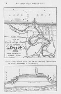
NOTES FOR THE MAP.
a, a, a, Ancient position of the river and shore line.
b, b, b, Position of river and shore line, 1796.
c, c, c, Lagoons old river bed , springs.
d, Outer of the Bluffs, e, e, e, e.
e, e, e, Clay bluffs and slides — ancient and modern.
Perry Monument, in Public Square.
h, i, Imaginary shore line at the close of 1000 years, without artificial protection.
NOTES FOR THE PROFILE ON BANK STREET.
A, A, Sand and gravel stratum.
a, a, a, Slide of October, 1849.
b, b, Older slides on the River side.
c, c, Layers of clay and sand.
1, Bones and grinder of an elephant.
2, Position of trees sticks and leaves.
There is in the clay very little tenacity in a dry state and thus when the waves have dissolved and carried away the foot of the bank it breaks down by its own weight. A long narrow strip of land at the crest, suddenly drops 10, 20, or 30 feet, pushing the previous slips, a, a, a, before it into the lake. The shore lines is temporarily carried forward and a bar of clay rises above the water level. At the top of the impervious clay bed the surface water which has settled through the sandy stratum, A, A, exudes everywhere in the form of springs. This water follows the crevices of the slides continually carrying the materials into the lake. The waves act rapidly upon the foot of the slope, softening and carrying away the part which was forced up from its bed. If the lake surface falls away, a sand beach is formed, consisting of coarse littoral materials , acting as a protection to the clay and quicksand. Thus for a time the shore line remains unchanged; but a series of storms or a rise in the water, renews the undermining process, and new slides occur.
When the city was surveyed the shore line was laid down by measurement on the town plat. A reduced copy of this survey made from the original which bears date, Cleveland, Oct. 1st 1796, is also inserted among the illustrations. A reduced copy of this survey made from the original which bears date, Cleveland, October 1st 1796, is also inserted among the illustrations.
The plan shows what changes have occurred since the lake assumed its present general level.
During the high water of 1838, the advance of the lake waters upon the town site, was so rapid that the corporation took measures to protect it. By comparing the surveys o 1796 and 1842 there had been a general encroachment of two hundred and five (205) feet., In 1806 or 1807, Amos Spafford sent his hired man, with a yoke of oxen to plow a patch of ground on the margin of the lake, which must have been not far from the Marine Hospital. At noon, the man chained his team to a tree, fed them, and went home to dinner. Returning in the afternoon his oxen were no where to be seen. Proceeding to the edge of the bank, the man discovered them still attached to the tree, quietly chewing their cuds, but the ground on which they stood had sank between twenty and thirty feet, carrying with it some of the new furrows, the trees and the oxen. Thus a belt of land about twelve and one half (121/2) rods in width was lost, along the entire front of the city. In one hundred years this would at the same rate have amounted to hundred years, have undermined the Perry monument. Before the close of a thousand years that part of the town north of Huron Street would have disappeared. The supposed new shore line and mouth of the river is shown by the line h, i, on the plan.
As the ancient surface of the lake went down, the Cuyahoga river cut a deep channel in the drift clay, with steep banks from which numberless springs issued. The ever shifting channels of streams undermine their banks continually, but in a different manner and with less regularity than the lake waters. On the river side the same slides have occurred, but not as many in number for the encroachment is not as rapid. Only one has been known since the settlement of the city, which took place near the foot of Light-House street, about the year 1808. Evidences of ancient slips were, however, abundant on both banks throughout the city. There were the same succession of benches or terraces, on the river as on the lake side. Wherever excavation took place for the grade of streets, the extent and exact outline of the old slides were as apparent as those of 1849, which were observed and sketched at the time. By taking up the springs that issue at the surface of the clay, and grading the bank to an angle of about 15 degrees, a smooth grassy slope is obtained, adapted for a park of exquisite beauty. Grinders of the elephant and mastodon are common in the superficial materials, which cover the indurated rocks of the west. A grinder is said to have been found in blue marly clay on the West Side many years since.
Remains of the elephas primigenius, the mastodon, megatherium, megalonyx, the horse, beaver, and some other animals, characterize the drift period. They existed prior to that geological era and through it to the alluvium, in which their bones are also found. They became extinct after the death had taken its present condition. The elephant, whose bones were discovered a few years since, in digging the coal vaults of the Merchants Bank, was about twelve feet below the natural surface. Another grinder of an extinct elephant was brought to light in the grade of Champlain street, which was about fifteen feet beneath the surface. It was secured by Dr. E. STERLING, and is now in the possession of Prof. NEWBERRY. This grinder had been worn by transportation, partially into the form of a rolled boulder; but the outlines are not wholly destroyed and the internal structure remains easily recognizable.
Pieces of buried timber, sometimes whole trees with numerous leaves, also characterize the northern drift. Layers of this ancient vegetation extend beneath the entire city. The wells from which water was originally procured, were sunk through the sand and gravel bed, A, A, to one of the impervious layers, c, c, where water is always found. It was frequently impure and even offensive, from the rotten layer which lies at the surface of the clay. There is more or less of it, distributed in thin dark layers through the clay, but it has collected in larger quantities at its surface. A white cedar, twenty (20) feet in length and six (6) inches in diameter, was taken up by the late John Willis, at the depth of eighteen (18) feet, in grading the bank at the Marine Hospital. The roots and some of the branches remained, and its strength was not wholly gone. There were several shorter pieces of ancient drift wood, found at about the same depth, which show the wearing action of the ancient surf upon a sand beach, like pieces of floodwood upon the present shore. Among the leaves in the mucky layers are cedar, spruce, and pine; and these are the most common kinds of timber, found in the drift material at other places.
To persons who have not become familiar, by observation, with the changes that have occurred on our planet, the assertion that there has been a period when this region was enveloped in ice, from 2,000 to 3,000 feet in thickness may appear monstrous .
To those who have examined the evidences which exist, in more than half the counties of this State, in support of such a conclusion; the proof is as conclusive as it is, that in Switzerland, the glaciers of the Alps, at one time reached down into the valley of the Rhone.
The slight changes of temperature which occur there now, affect the extent of the glaciers. A few degrees rise in the thermometer; diminishes the area of the iced fields; and a few degrees of depression enlarges it.
In ancient times, Alpine glaciers extended across the valley at Geneva lake, carrying boulders of rocks from the summit of the Range, which were dropped in the low ground, when the ice disappeared.
Beneath the present glaciers, the rocks are polished, ground and striated, by the projecting points of boulders; firmly held in the ice, as it moves towards the lower levels. The rocks in districts from which the ice has disappeared, and where there are now cultivated farms and cities, are worn and striated in the same manner.
Greenland has within a few years been closely observed by Dr. Rink, a Danish naturalist and by Dr. Hayes, of the American expedition under Dr. Kane. There, a large part of a continent is found to sustain a vast glacier; which has a slow but restless motion outward toward the ocean. The cause of this motion, constitutes one of the most brilliant discoveries of Agassiz. In Greenland, there is, in places, a fringe of territory next the sea, not invaded by ice; which is variable in its extent, like that at the foot of the Alps. About 200 years since. the Moravians had mission establishments on the eastern coast of Greenland, which are now buried under snow and ice. The temperature of that country is becoming lower. The great central field of universal frost, is gaining upon the territory where vegetation exists. Towards the northern part, glaciers come to the sea, with a front of more than a thousand feet high; scratching and grinding the rocks precisely as they do in Switzerland. They push themselves along the bottom of the ocean, until there is buoyancy enough to cause them to float, when they are broken into large blocks, and range the sea, in the form of ice bergs.
It is only necessary to bring the temperature of Greenland down to our latitude, and the same results would follow. The moisture of the air derived from the ocean, would be deposited upon the earth in the form of snow, instead of rain. It would thus accumulate, century after century, filling up the valleys, rising to the tops of the mountains, effectually preventing the growth of trees, and plants, and thus gradually driving men and animals from the country.
Throughout the western States and Canada, are lines etched upon the rocks, the same as are seen in Greenland and on the Alps; produced by the movement of glaciers. They may be seen in hundreds of places in Ohio, when the rocky surface is cleared of its earthy covering. They are very common in the cellars at Sandusky, and on Kelly’s Island, where the lime rock is thoroughly polished, having marked grooves, warped surfaces, and channels parallel to each other.
On the summit of Coal Hill in Tallmadge, Summit County, Ohio, at an elevation of 625 feet above Lake Erie, and 1189 above the Ocean, the coarse grit of the coal series is smoothed and scratched over a space of several rods.
At the old grindstone quarries in Euclid, Cuyahoga County they are very distinct and straight, bearing about South 20 degrees East by needle.
There is a good exposure of glacial etchings on the sand rock, near the North line of Austintown, Mahoning County, in the North and South center road.
The most southerly point in Ohio where they have been observed; is at Light’s quarry, seven miles North of Dayton, their bearing being South 26° East. For the benefit of those who have no opportunity to examine the work of the ancient ice gravers, I insert a reduced copy from the fac simile of a polished slab of limerock, near the Light House at Sheboygan, Wisconsin. The waters of Lake Michigan, are there wearing away a bluff of red clay, of about the same height as the blue clay deposit at Cleveland; but the rock on which it rests is nearly level with the water. A belt of this scratched rock, several rods in width, recently uncovered, extends along the shore at the foot of the clay bluff, beneath which the ice etchings extend. About three miles in the interior, the Sheboygan River has cut a channel in the same red clay down to the rock,
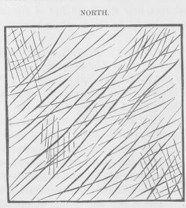
which has a depth about the same as the valley of the Cuyahoga, within city limits. Where the rock projects beyond the clay, it is smoothed, and worn away by attrition, precisely as at the Light House, and the lines have the same direction. If the covering of clay, from the Sheboygan River to the lake shore was all cleared away, there would be several thousand acres of this polished rock exposed, of which this is intended to be a fac similie.
The most conspicuous lines are due north-east and south-west, but as usual, there is more than one set. Such is the condition of the strata over the States bordering upon the lakes and the St. Lawrence. During the progress of the various geological surveys in the Northern States, and in Canada, many hundreds of observations have been made, upon the direction of these lines.
Where there are hard spots in the rocks, able to resist the grinding process better than the surrounding parts; a narrow ridge is left on the southerly side, like the snow which forms in the lee of a pebble in a driving storm. The northern faces of mountains, and of rocky eminences, are abraded, while the southern faces are not. But the most conclusive evidence that the movement was from North to South, is found in the transportation of fragments of northern rocks to points always southerly from their position in situ. The boulders of Ohio are principally trap, gneiss, granite, breccia, and conglomerate; from strata that are in place on the shores of Lake Superior, and which exist in no direction. The movement was modified by the topography of the country, pursuing in general, the course of the great valleys, such as those of the Kennebec, the Connecticut, and the Hudson Rivers.
In New England, the ice marks are found at an elevation of 3000 feet above the sea, which is higher than the highest land in the western states.
In the valley of the St. Lawrence, the course of the movement was south-easterly until, the east end of Lake Ontario is reached. At Buffalo, it was South 30° West. On Lake Superior it had the same general bearing, except in the minor valleys, or where mountains turned it aside temporarily. The opening between Lake Huron and Lake Michigan, at the Straits of Mackinaw, gave it a westerly direction, as far as the mouth of Green Bay. On the summit of the Iron Mountains of Marquette County, Michigan; of the Copper Range of Point Kewenaw, and the Mesabi Range in Minnesota, the markings are as distinct as they are at Lake Erie; and their bearing is uniformly south-westerly. How the change of temperature, of the glacier epoch was brought about is a question still under discussion. Such changes have occurred much earlier in the history of the earth, and are probably due to astronomical causes; involving immense periods of time. During the era of the coal, a tropical climate existed as far North as Melville Island, in the Arctic Sea.
The origin of motion in such wide spread fields of ice, is thought to be understood. Agassiz spent several seasons in the Alps observing the movements there. He has demonstrated that the expansion which arises from freezing at the center of the mass, find relief only towards the edges, and consequently, on the side which is thawing, there must be motion. This is very small but irresistible, and continuing for thousands of years in one direction, produces monstrous results.
If an ice field enveloped the northern hemisphere, its thawing edge would be on the side of the equator. Consequently, the movement would be southerly, and would be greatest along the front, where dissolution was taking place. But the line of equal temperature, are not coincident with parallels of latitude.
Across this continent and through Europe, they are oblique, bearing to the North as we proceed westward.
This was probably the case, at and before the age of ice. Thus the southerly edge of the continental ice field, would not bear East and West, but north-westerly and south-easterly, modified by the elevation of the country. In that case, the motion would be at right angles to the Isothermal lines, or from north-east to south-west. There is an exception to this, in the bearing of the stria across the westerly part of Lake Erie, but here the Southern limit of the boulders of northern rocks, forms a curve, and is nearly parallel with the southerly shore of the lake.
Such is supposed to be the manner in which the beds of clay, sand and gravel were formed, on which the city of Cleveland rests.
