Main Body
EARLY MAPS OF THE LAKE COUNTRY
Upon the geography of the region of the Lakes, there is nothing, based upon personal observation, earlier than Champlain’s map, a portion of which is given on the next page. He spent his life among the Indian tribes of the valley of the St. Lawrence, either in a friendly or a warlike character. Those on the North or the St. Lawrence,(originally St Laurent); were secured to the French interest by his personal influence. He always went with them across the river southward, to make war upon their enemies, the Iroquois, who were friendly to the English. In 1634, Champlain published his map of New France. The French had not, at this time , dared to venture upon Lake Erie, neither had they the benefit of information from Indians, who lived upon its shores. In his expedition of 1615 against the Onondagoes, on the waters of the Oswego River, and the Senecas at Canandaigua Lake, Champlain obtained some knowledge of that country.
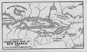
His route is shown on the map by dotted lines; and the position of the Seneca Fort by the letter a . From the country of the “Antoronons” or Senecas, on the head of the Genessee River; and of the “Carantouannais,” on the head waters of the Susquehanna, an Indian road or trail, led away to the westward, and the streams running north into Lake Erie. The Falls of Niagara are noticed only as a rapid or sault, like the other rapids of the St. Lawrence. From thence, a grand strait, with Islands, connecting Lake St. Louis, or Ontario with Lake Huron, is all the representation given of Lakes Erie and St. Clair. Champlain only knew that his “Mer Douce” had a connection with Lake Ontario , but of the existence of another great lake, between them, he was clearly ignorant. His route to Lake Huron was always through the friendly tribes, by way of the Ottowa River, and “Lac de Biserenis” or Lake Nepissing. Evidently, he had not explored the “Grand Lake” (Michigan) or Lake Superior. The “Puants” or Winnebagoes, who occupied the north-western parts of Lake Michigan, he supposed were north and east of Superior. The Chippeways, Ojibways, or Sauteurs, were at that time, as they have been since, the masters of the shores of that lake. If Champlain had been upon the waters of Lake Michigan, he would not have put the sault, at the outlet of that lake, instead of Superior. Neither would he have represented the last named lake, as a diminutive body of water, not larger than Lake Nepissing. The fact of the existence of copper, he derived from the Indians.
But grotesque as his map appears to us, it possesses much interest. It shows where the savage nations were located, whey they were first encountered by the whites. The Iroquois held the waters of Lake Champlain, the Hudson River, and the Upper Susquehanna. On the North Shore of Lake Ontario were the Hurons, afterwards known as the Wyandots. On the North Shore of Lake Erie, the “Petuns,” or Tobacco Indians were located.
Not long before the Iroquois achieved their first great victory over the Eries, which occurred about 1655, they expelled the Neutral Nation from the shores of the Niagara river. The Iroquois called the Neutrals, the Nation of the “Cat,” meaning the wild cat, an animal of the family of the lynx. By the French, the Eries were also known as Cats, but this name they applied to the raccoon. In this way, the two Nations are confounded. Their fate was alike, but they were not even allies. The Eries, under the name of Erigas, remained a long time in Ohio, having been driven from the Genessee river, past Buffalo, to the heads of the Scioto. They were originally of the Iroquois stock, speaking a dialect of the same language. As usual, when people of the same lineage become enemies, their hatred is more fierce and lasting than where there is no community of blood.
At the eastern end of Lake Michigan, a great river comes in from the South, whose head waters are as low in latitude as the capes of Virginia. A large river discharges into Lake Huron, near the western portion, opposite an island. On this is located the “Gens de Feu,” or nation of the Fire, since called the Mascoutens. Another large river from the south, discharges into what answers to Lake Erie. On the sources of the three last named streams was the nation “which has plenty of Buffaloes.” Numerous Indian villages, fields, and graves, are represented on these rivers, and throughout all the country. There are also abundant mountains, in all parts of the western and north-western country, as well as in New England and Virginia.
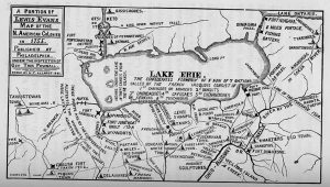
LEWIS EVAN’S MAP-1755.
Neither had the English much reliable knowledge of Lake Erie, until after the year 1700. As soon as peace was secured by the French, with the Iroquois, they hastened to possess the country west of the Allegheny mountains. The English were equally hasty in opposing them. Lewis Evans, of Philadelphia, assisted by Governor Powwall, of New Jersey, between 1740 and 1750, gathered materials for the map of 1755. Captain Thomas Hutchins, who was the Engineer to Colonel Boquet’s expedition of 1764, also published a map, embracing a part of Lake Erie, and the Upper Ohio. John Fitch, the great American improver of steamboats, and who invented more of its useful parts than any other man, published a map of the Ohio country in 1784 or 1785. In March, 1780, he was made prisoner by Indians, at Blennerhasset’s Island, near Marietta, on the Ohio, and taken by them through the country to Detroit. He obtained from them what information he could; drew, engraved and printed, the map with his own hands.
Evans included in a general sketch, all the country westward from the sea coast, to the Mississippi River, which is remarkably accurate. His detailed map extends no farther West than the Great Miami. As early as 1670, the Jesuit Fathers published a map of Lake Superior, which appears to have been corrected by celestial observations. It seems impracticable to construct a chart of so large a tract, with so much geographical accuracy, without such corrections. The positions of important points on Evans’ map, do not appear to have been determined by astronomical instruments; but his sources of local information, must have been very numerous and reliable.
His title is quite a geographical memoir, and reads thus:
“A GENERAL MAP
OF THE
MIDDLE BRITISH COLONIES IN AMERICA,
VIZ:
VIRGINIA, MARILAND, DELAWARE, PENSILVANIA, NEW JERSEY, NEW YORK, CONNECTICUT AND RHOD ISLAND;
OF
Aquashuonigy Country, of the Confederate Indians, comprehending Aquaishunigy proper, their place of residence; Ohio and Tiiuxsaxrunthe, their deer hunting country, Couxsaxrage and Skaniadarade, their beaver hunting countries of the Lake Erie, Ontario and Champlain, and a part of New France; wherein is also shown the ancient and present seats of the Indian Nations.”
NOTE.-“The Confederates, July 19, 1701, a Albany, surrendered their beaver hunting country to the English , to be defended by them for the said Confederates, their heirs and successors forever, and the same was confirmed Sept. 14, 1728, when the Senecas, Cayugaes and sixty miles inland to the same for the same use.”
A comparison of the early maps, gives the best history of the migrations of Indian tribes. Their rapid extinction, is also made conspicuous by such comparisons. In place of the “Petuns” of Champlain, on the North of Lake Erie, towards the Falls of Niagara, are, according to Evans, the “Sissisoquies.” Between the Oswego and Genessee (Kashuxca) Rivers are the “Cayugaes”; on the heads of the Genessee, the Senecas; and in Ohio, the Erigas, or Eries. No notice is taken of the Neutral Nation. The “Chawanes'(Shawnees and Shawanese,) were then on the Ohio, around the mouths of the Scioto, and the Kenhawa. On the Great “Mineami,” (Miami,) were the “Tawixtawis,” and the Mineamis. The Hurons, Wyandots, or “Wiandots,” had been pushed from the North Shore of Lake Ontario, to the western part of Lake Erie, embracing both shores.
For local details, the map of Evans’ is a great advance upon Champlain’s. The outlines of Lake Erie are too large every way, but the resemblance to nature is easily traced. Several of the Indian trails and portages are given, showing their principal routes of travel, by land and by water
A great war path extended southerly from the Tawixtawi towns, at the Forks of the Maumee, to the French post on the Great Miami; afterwards known as Loramies; thence to the mouth of the Scioto, and to the Blue Licks in Kentucky. From Loramies or the Piqua towns, another led eastward to the Delaware towns, on the Scioto; and thence across the Hockhocking, probably at Lancaster, to the White Woman’s town, at the forks of Muskingum, near Coshocton. Coal is laid down on the Tuscarawas, near Bolivar; petroleum on the Ohio, near Yellow Creek; and salt water on the Mahoning River, in Trumbull county.
At the issuing of this map, the French were in possession of all parts of Lake Erie, and its waters. No Englishman had traversed this country, unless it was some unknown prisoner among the Indians. The first of these we know of, was here in 1754-5. Huske’s map prefixed to Douglass’ summary; a general history of North America, 1760, has the following title:
‘“A Map wherein the errors of all preceding maps, British, French and Dutch, respecting the rights of Great Britain, France and Spain, and the limits of each of his Majesty’s provinces are corrected.”
Carrying Places Between the Ohio and Lake Erie.
From the Topographical Description, &c. By Capt. Thomas Hutchins, 60th Regiment, London, 1788.
“The Canawagy Creek, (Chatauque) when raised by freshets, is passable with small batteaux, to a lake, (Chatauque) from whence is a portage of twenty miles, to Lake Erie, at the mouth of the Jadagque, but this is seldom used, as the Canawagy has scarcely any water in a dry season.”
Chatauque is no doubt derived from “Jadagque,” or “Jadaixqua, according to Evans.
“French Creek affords the nearest passage to Lake Erie, being navigable by a very crooked channel, with small boats to Le Beuf. The portage thence to Presque Isle is fifteen miles.”
“Beaver Creek has sufficient water for flat boats. At Kishuskes, about sixteen miles up this creek, it has two branches, which spread opposite ways. One interlocks with French Creek and Cherage; the other with Muskingum and Cuyahoga, on which, about thirty-five miles above the forks, are many salt springs. It is practicable for canoes about twenty miles further.”
“From Muskingum to Cuyahoga, a creek that leads to Lake Erie, which is muddy and not very swift, and nowhere obstructed with falls or rifts, is the best portage between the Ohio and Lake Erie.”
“The mouth is wide and deep enough to receive large sloops from the lake, and will hereafter be of great importance.”
“The lands on the southern shore of the lake, and for a considerable distance from it, for several miles East of the Cuyahoga, appear quite level, and are extremely fertile.”
